Visita de Salog (Goa) Survey
- Post by: admin
- July 4, 2022
- No Comment
Doing Geology in Archaeology:
A reflection on Visita de Salog Field Survey, June 30, 2022
Noel Jay G. Roxas
As a geology student when I join the Bicol Archaeological Project 2022 (BAP), I have the same question as my parents had asked me: “What am I doing in a project that aims to understand the pre-colonial Bikol? What’s the connection of geology in human belief, human settlement pattern, human culture?” As for the 1st week of the BAP, I slowly answered these questions: “There’s a lot of geology in Archaeology”.
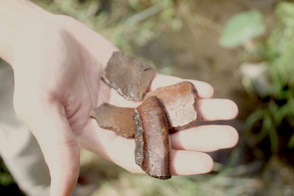
On June 30, 2022, we have a field survey in Visita de Salog that is said to be a place where the Spanish colonizer had a first contact on the town of the now Goa. The term “Visita” literally means “visit”. It also means a satellite branch of a parish where priest can occasionally do his priestly duty. Given this information, the assumptions here is that the area is already has a community settlement before the colonial contact that is enough to create a branch of Christian enterprise.
Now, with a quick recap of how the term “visita” came in, we back to the question “What is the connection of geology in archaeology?”.
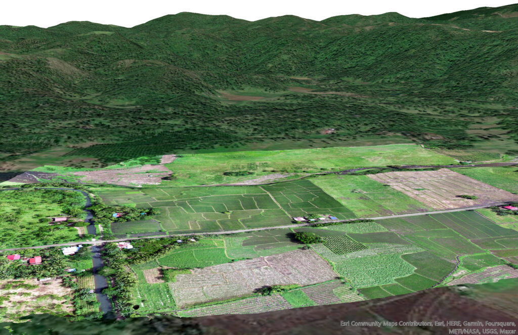
During the field survey, we saw that the area is near a riverbank. This riverbank is connected to Lagonoy River that is, geologically speaking, every drainage system aims to endup to a larger body of water – in this case, the Lagonoy Gulf. As history can (re)tell, Lagonoy Gulf plays a significant role in pirates and Spanish ships. The connection of Lagonoy river to the area makes a sense that the river plays an important role in the historical narrative of Partido deep history. Now, we trace this tributary with the use of geophysical instruments such as available satellite images.
Another example. As Maddie Yakal told us that we aim to find settlement pattern of the area by finding (paleo)waterways as an indicator of past irrigation system (see Acabado, 2016), I quickly think of the river (again). She told us with stratigraphic patterns such as coursing up pattern of sediment (bigger rocks go in the upper layer while finer grains in the bottom layer), I also think that the area is also a past waterway system since water plays an important role in “transporting and segregating” these sediments (Charlton, 2008). The problem I realized, natural tributary can also do the same way without doing an human-made irrigation system. Here comes the humanizing part of thinking critically in testing the hypothesis. We differentiate human-made and natural tributary with its contour. Archaeology could tell the former while geology can tell the later. However, both use geologic methodology in understanding the stratigraphy.
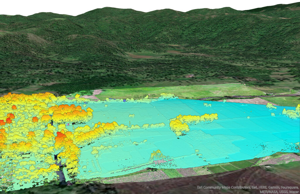
Aside from understanding the (paleo)waterways, it is important to note that geophysical methodology such as Light Detection and Ranging (LiDAR) can also be used in archaeology (Wiseman and El-Baz, 2007). During the field survey, Robin do an airborne LiDAR survey. Although both geology and archaeology aim to determine the 3D visualization of the area, LiDAR in geology focused more on natural contours of the landscape while archaeology aims to determine human-made patterns that can only be viewed above our head.
On the end of the day, I found geology and archaeology as connected. We cannot separate both entities because of its individual objectives, but we could put both in the same page to have a deeper understanding and context of our landscape. Besides, geology makes archaeology more scientific in understanding the landscape and archaeology makes geology more humanized. I found multidisciplinary approach more useful in this field school. I must say, I’m not lost on taking a path of a different discipline, especially if both paths are overlapping.
REFERENCES
Acabado, S. 2016. Antiquity, Archaeological Processes, and Highland Adaptation: The Ifugao Rice Terraces. Quezon City: Ateneo de Manila University Press pp. 15-16
Charlton, R. 2008. Fundamentals of Fluvial Geomorphology. Oxon: Routledge.
Wiseman, J., El-Baz, F. 2007. Remote Sensing in Archaeology. New York: Springer.